
Earth’s Interior: Seismic Evidence and Mantle Convection
Students interpret seismic-wave and global mapping data to develop a model explaining Earth’s layered interior, mantle convection, and the spatial pattern of tectonic activity.
Illustrations are auto-generated and may be placeholders. They can be refreshed to match the narration.
Earth’s Hidden Interior
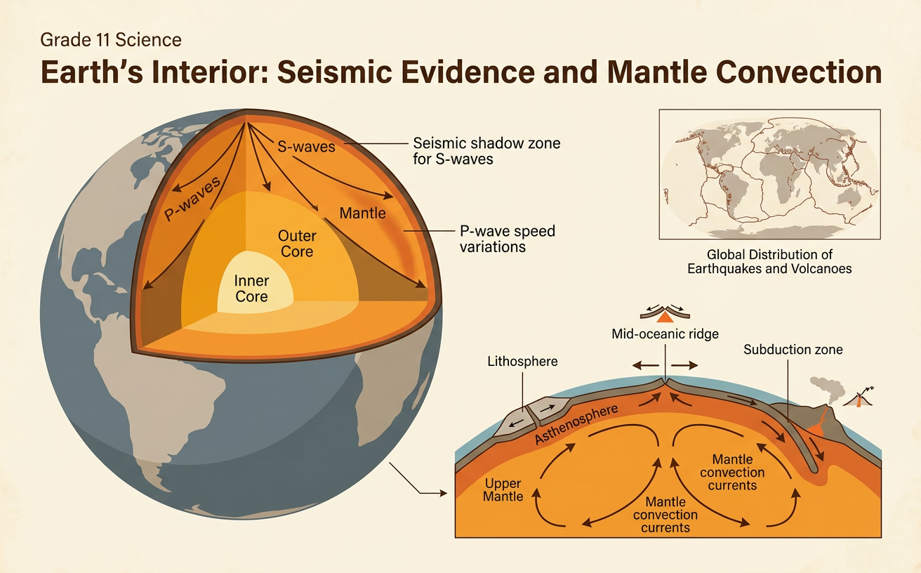
Earth’s interior cannot be observed directly beyond relatively shallow drill holes, so scientists build models from indirect evidence. Earth is organized by composition into crust, mantle, and core. It can also be organized by physical behavior: the rigid lithosphere includes the crust and uppermost mantle, while the softer asthenosphere beneath it can flow slowly. Deeper mantle remains solid under enormous pressure. The core has a liquid outer region and a solid inner region, both composed mainly of iron and nickel. Density, temperature, and pressure generally increase with depth. For example, Earth’s average density is much greater than the density of surface rocks, indicating that denser material must exist inside the planet. Seismic waves and laboratory measurements provide additional evidence for the locations and properties of these hidden layers.

Reading Seismic-Wave Evidence
Earthquakes release P waves and S waves that travel through Earth and are recorded by seismometers. P waves compress material in the direction of travel and can move through solids and liquids. S waves move material perpendicular to their travel direction and cannot pass through liquids. Wave speeds change when density, composition, or physical state changes, causing waves to refract, or bend. After a large earthquake, no direct S waves are detected more than about 103° from the epicenter, providing evidence for a liquid outer core. Refraction of P waves produces a P-wave shadow zone from about 103° to 142°. For example, if one station records both P and S waves while a distant station records P waves but no S waves, the missing S waves support the conclusion that liquid material lies along their expected path.

Mapping Earthquake and Volcano Patterns
Global maps show that earthquakes and volcanoes are concentrated in narrow belts rather than distributed randomly. These belts commonly outline tectonic plate boundaries. At divergent boundaries, shallow earthquakes and volcanism occur where plates separate and new oceanic crust forms. Transform boundaries mainly produce shallow earthquakes as plates slide past one another. At subduction zones, earthquake locations become progressively deeper beneath the overriding plate, forming an inclined Wadati-Benioff zone, while a volcanic arc develops farther inland. For example, maps of the western coast of South America show an offshore trench, earthquakes that deepen eastward, and a chain of Andes volcanoes. Together, these spatial patterns indicate that the Nazca Plate descends beneath the South American Plate. Some volcanoes, such as those in Hawaii, occur over mantle hotspots away from plate boundaries.

Modeling Mantle Convection
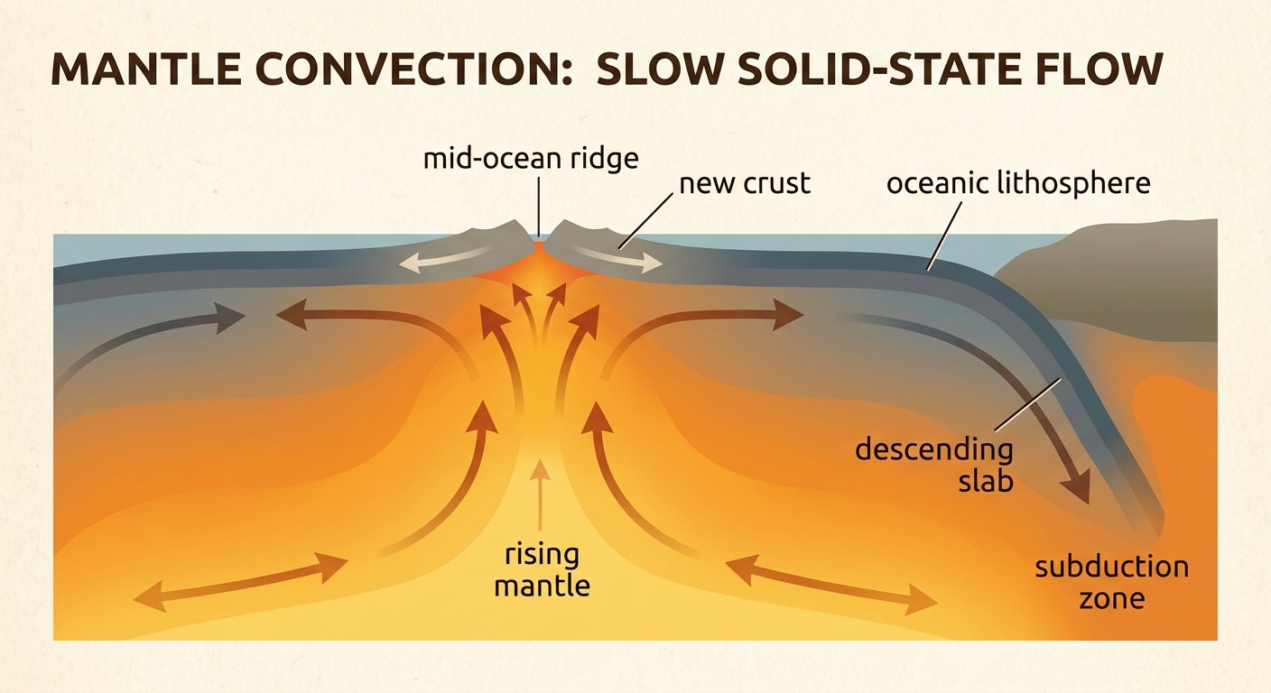
Mantle convection is the slow movement of solid rock driven by differences in temperature and density. Heat remaining from Earth’s formation and heat produced by radioactive decay warm the interior. Hotter mantle material expands slightly, becomes less dense, and tends to rise, while cooler, denser material tends to sink. Although the mantle is solid, it can deform and flow over millions of years under sustained stress. This motion transfers thermal energy and cycles mantle matter without requiring the mantle to be liquid. For example, hot mantle may rise beneath a mid-ocean ridge, partially melt as pressure decreases, and contribute magma to new crust. Far away, an old oceanic plate cools, becomes denser, and sinks at a subduction zone. A useful model should show this linked rising, lateral movement, cooling, and sinking rather than a rapidly circulating liquid.
Connecting Convection to Plate Motion
Plate motion and mantle convection are parts of one interacting system. Rising mantle and decompression melting help create new lithosphere at mid-ocean ridges. As this lithosphere moves away, it cools, thickens, and becomes denser. Gravity allows elevated ridge lithosphere to slide outward, a process called ridge push. At subduction zones, a cold, dense oceanic slab sinks and pulls the rest of its plate behind it; this slab pull is a major driver of plate motion. Flowing mantle can also exert traction on plate bases. For example, seafloor ages in the Atlantic increase symmetrically away from the Mid-Atlantic Ridge, while GPS measurements show North America and Europe moving apart. A complete model connects these measurements with ridge formation, mantle flow, and plate movement, while recognizing that convection does not simply carry passive plates on fixed circular currents.
