Evidence of Moving Tectonic Plates
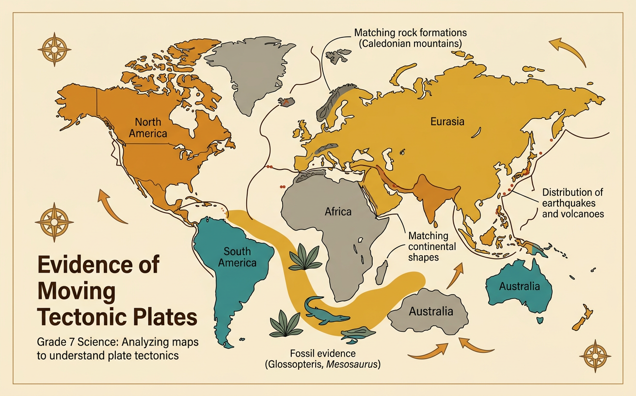
Students analyze maps of fossils, rock formations, earthquakes, and continental shapes to explain how evidence supports the theory of plate tectonics.
Illustrations are auto-generated and may be placeholders. They can be refreshed to match the narration.
Continents as a Geologic Puzzle
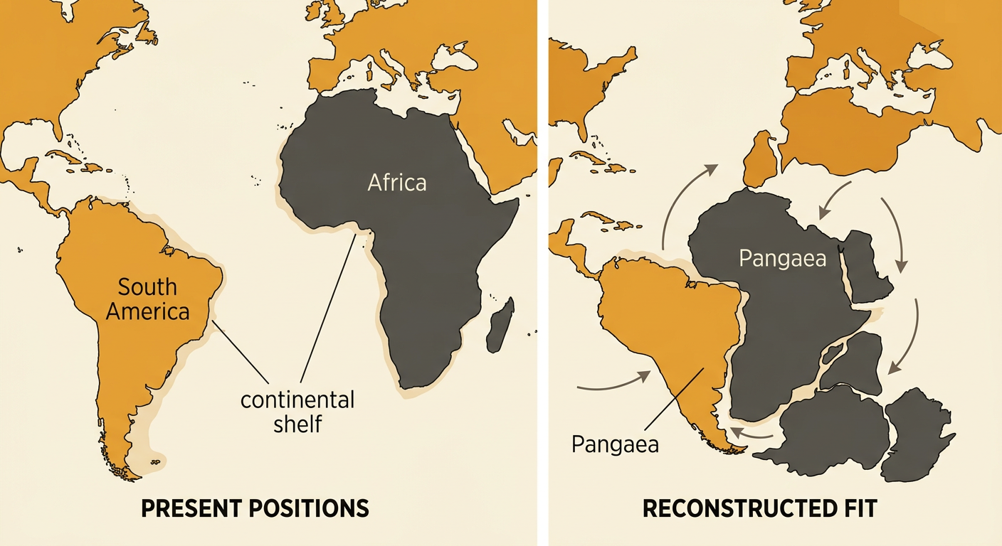
A world map shows that some continents have coastlines that appear to fit together. The eastern coast of South America and the western coast of Africa are a well-known example. Their fit becomes even clearer when scientists compare the edges of the continental shelves, the submerged borders of the continents, rather than today’s shorelines. Shorelines change through erosion, deposition, and sea-level changes, so shape alone cannot prove that continents moved. However, the matching edges are an important clue. When the continents are repositioned, they form part of a larger ancient landmass called Pangaea. Scientists use this geographic pattern together with fossils, rocks, and other evidence to explain that South America and Africa were once joined and later separated as tectonic plates moved.
Matching Fossils and Rock Formations
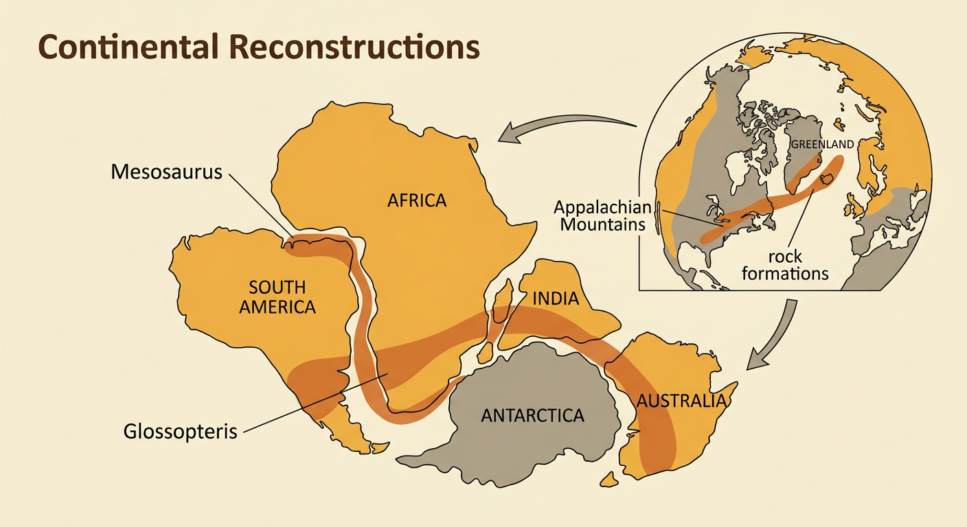
Identical fossils and related rock formations on continents now separated by oceans provide strong evidence of past plate motion. Fossils of Mesosaurus, a small freshwater reptile, have been found in both South America and southern Africa. Because this animal was not able to cross a wide saltwater ocean, the continents were probably connected when it lived. Fossils of the seed fern Glossopteris also occur across South America, Africa, India, Antarctica, and Australia. In addition, mountain belts and rock layers can match in age, type, and structure across oceans. For example, rocks in the Appalachian Mountains of North America correspond to rocks in Greenland, Ireland, Great Britain, and Scandinavia. These patterns make sense when the continents are assembled into earlier positions and the separated formations line up.
Mapping Earthquakes and Volcanoes
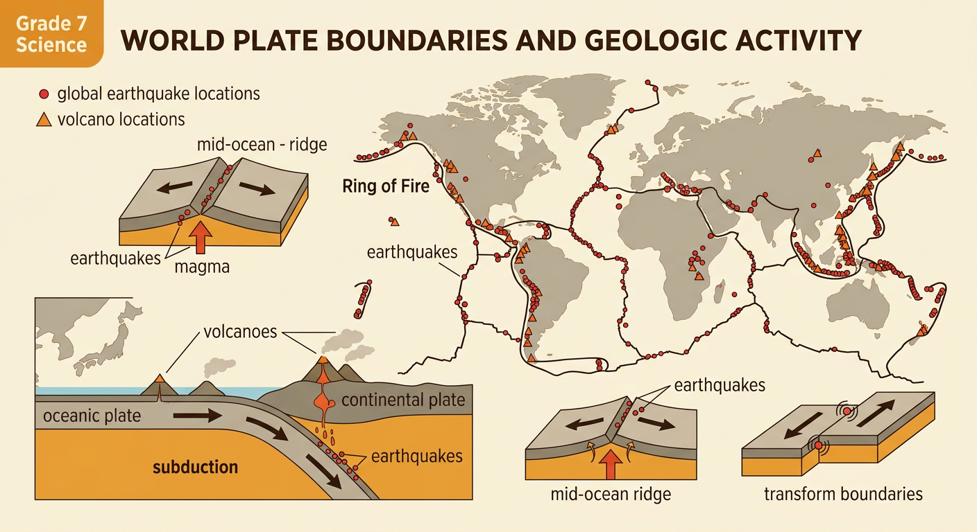
Earthquakes and volcanoes are not randomly scattered across Earth. When their locations are plotted on a world map, they form long, narrow belts that outline many tectonic plates. Around the Pacific Ocean, frequent earthquakes and volcanoes form the Ring of Fire. Near Japan, one oceanic plate moves beneath another plate in a process called subduction. This motion produces a line of volcanoes and earthquakes that can occur at increasing depths beneath the continent or island arc. Along mid-ocean ridges, shallow earthquakes and volcanic activity occur where plates move apart and magma rises. Some plate boundaries, such as transform boundaries, produce many earthquakes but few volcanoes. By comparing the locations and depths of earthquakes with volcanic chains and seafloor features, scientists can identify where plates meet and infer how they move.
Identifying Plate Boundaries
Scientists identify plate boundaries by analyzing landforms, earthquake patterns, volcanoes, and the directions of plate motion. At a divergent boundary, plates move apart and new crust forms. The Mid-Atlantic Ridge is a divergent boundary where seafloor spreading slowly widens the Atlantic Ocean. At a convergent boundary, plates move toward each other. Along the western edge of South America, the oceanic Nazca Plate moves beneath the South American Plate, creating the Andes Mountains, volcanoes, and earthquakes. At a transform boundary, plates slide horizontally past each other. The San Andreas Fault in California is an example and produces frequent earthquakes but little volcanic activity. A map that combines these observations helps scientists classify a boundary instead of relying on one clue. Boundary types also explain why different regions experience different geologic hazards.

Constructing an Evidence-Based Explanation
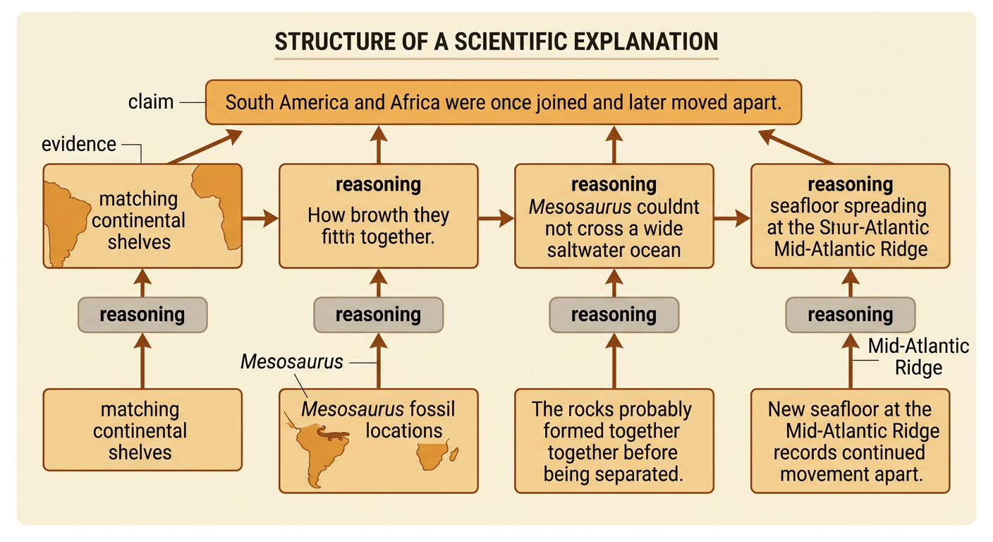
A strong scientific explanation includes a claim, relevant evidence, and reasoning that connects the evidence to the claim. Consider the claim that South America and Africa were once joined and later moved apart. Evidence includes their matching continental shelf shapes, Mesosaurus fossils on both continents, corresponding rock layers, and the Mid-Atlantic Ridge between them. The reasoning explains why these observations matter: a freshwater animal could not have crossed a wide ocean, matching rocks likely formed together, and new seafloor at the ridge records continued separation. No single clue tells the whole story, but several independent patterns support the same conclusion. Scientists also evaluate limitations, such as changes to coastlines, and look for evidence from different sources. Combining geographic maps, fossil data, rock records, and modern geologic activity produces a well-supported explanation of past plate motion.