
How Communities Prepare for Floods
Students use a short text, map, and graph to examine flood risks and recommend a way a community can reduce harm.

Illustrations are auto-generated and may be placeholders. They can be refreshed to match the narration.
What Causes Community Flooding?
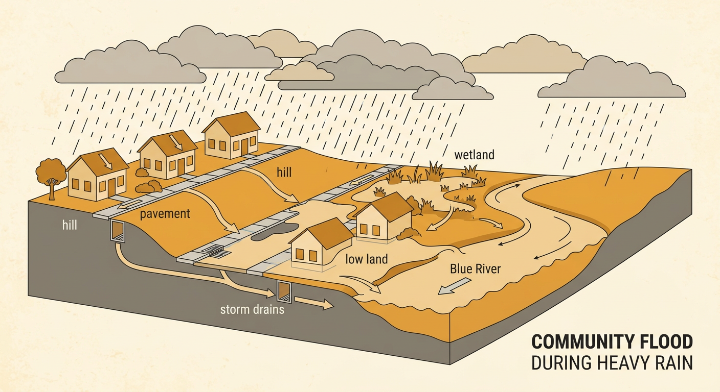
A flood happens when water covers land that is usually dry. Heavy rain can make a river rise until water spills over its banks. Flooding can also happen when rain falls faster than soil and storm drains can absorb or carry it away. Snowmelt and coastal storms may add even more water. Features of a community affect its risk. Pavement and rooftops do not soak up much rain, so water flows quickly toward low areas. Wetlands and healthy soil can hold some water and slow its movement. For example, after several hours of heavy rain, water in the Blue River may spread into nearby streets. Homes on low land beside the river face greater risk than homes on a hill. Flood maps help people identify these differences and prepare before a storm.
Read for Evidence
Read this report: Riverbend received five inches of rain in two days. The Blue River rose above its banks and flooded twelve homes on Water Street. The town’s wetland held some rainwater, but a parking lot sent runoff quickly toward the river. No one was hurt because weather alerts gave families time to move to the community center on Hill Road. Town leaders are considering adding a rain garden near the parking lot. Ask questions that can be answered with evidence from the report. What caused water to move quickly toward the river? The report says the parking lot sent runoff toward it. How did alerts reduce harm? They gave families time to move to safety. When answering, refer directly to words, facts, or details in the text rather than making an unsupported guess.

Interpret Flood-Risk Data
Riverbend leaders counted homes in three flood-risk zones. A scaled bar graph shows 24 homes in the high-risk zone, 16 homes in the medium-risk zone, and 8 homes in the low-risk zone. Each graph interval represents 4 homes. To compare two bars, subtract their values. The high-risk zone has 8 more homes than the medium-risk zone because 24 minus 16 equals 8. It has three times as many homes as the low-risk zone because 24 is three groups of 8. Altogether, the zones contain 48 homes because 24 plus 16 plus 8 equals 48. Always read the graph title, category labels, scale, and units before answering. The data suggest that the community should give special attention to the high-risk zone, where the greatest number of homes could be affected.

Explore Community Adaptations
Communities adapt to floods by changing buildings, land, routines, and public spaces. Riverbend could raise homes above expected floodwater, protect wetlands that store water, plant rain gardens that absorb runoff, and mark evacuation routes to higher ground. People’s culture can influence which adaptations they choose. Culture includes shared traditions, knowledge, jobs, and ways of using places. For example, families in a river community may depend on fishing and hold events near the water. Instead of blocking all access to the river, they might protect a wetland, build raised walkways, and create signs that show safe routes during floods. Residents may also share knowledge from past storms when planning. A useful adaptation should reduce harm while respecting how people live, work, travel, and care for important community places.

Compare Possible Solutions
Riverbend is comparing three solutions. A rain garden near the parking lot would absorb runoff, cost less than a large wall, and provide plants for insects, but it could not hold all the water from a major flood. Raising homes in the high-risk zone would protect buildings from shallow floodwater, but it would be expensive and would not protect roads. A floodwall could block some river water, but it would cost a great deal, require maintenance, and might move water toward another area. To judge each design, ask how much harm it could reduce, what it costs, whom it protects, and whether it creates new problems. No design removes every risk. For example, the rain garden has merit because evidence shows that the parking lot sends runoff toward the river, so slowing that runoff addresses a known cause.

Recommend a Community Plan
A strong recommendation makes a clear claim and supports it with evidence from the text, map, and graph. One possible claim is: Riverbend should build a rain garden beside the parking lot and improve the evacuation route to Hill Road. The report states that the parking lot sends runoff quickly toward the river, so a rain garden would slow and absorb some water. The map shows that Hill Road is on higher ground, making it a safer destination during a flood. The graph shows 24 homes in the high-risk zone, which is 8 more than in the medium-risk zone. Clear route signs and alerts could help those families leave early. This plan will not stop every flood, but it can reduce runoff and help people reach safety. Leaders should also check the rain garden, practice evacuation drills, and revise the plan using new flood data.
