Mohenjo-Daro: What City Planning Reveals About the Indus Valley
Students analyze maps and archaeological evidence from Mohenjo-Daro to explain how streets, wells, and drainage systems reflect the priorities and organization of Indus Valley society.

Illustrations are auto-generated and may be placeholders. They can be refreshed to match the narration.
Introducing Mohenjo-Daro
About 4,500 years ago, Mohenjo-Daro was a major city of the Indus Valley civilization. Its ruins lie in present-day Pakistan near the Indus River. The city developed during the civilization’s mature period, about 2600 to 1900 BCE. Archaeologists have uncovered brick buildings, streets, wells, drains, workshops, and a large public water structure called the Great Bath. These remains show that residents built a complex urban community. For example, many structures used baked bricks made in consistent proportions, suggesting that builders followed shared practices. However, the Indus writing system has not been deciphered, so historians cannot read the city’s own written records. They must combine artifacts, buildings, and maps to interpret how people lived. Archaeological evidence can support strong conclusions, but it does not answer every question with certainty.

Reading the City Map
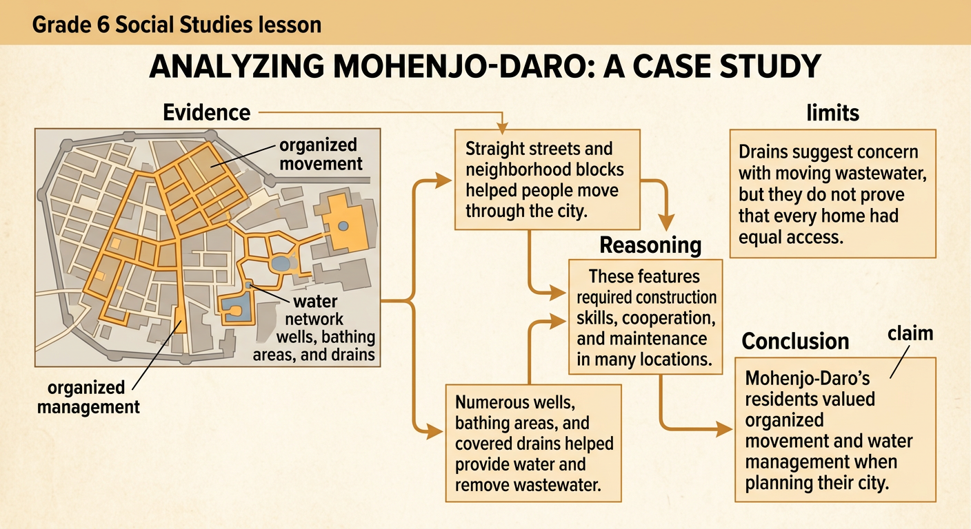
A map of Mohenjo-Daro reveals deliberate planning. Many streets run in fairly straight lines and meet at near-right angles, dividing neighborhoods into blocks. Larger streets connected important parts of the city, while narrower lanes provided access to homes and work areas. The city included a higher western mound with major structures and a much larger lower city with houses, wells, and workshops. Buildings did not form a perfectly even grid, and the city changed through repeated construction and rebuilding. A concrete clue is the placement of many house entrances on side lanes instead of the busiest streets. This may have reduced crowding and provided greater privacy. When reading the map, students should compare street width, direction, building location, and access points. These visual patterns show planning, but they do not reveal exactly who made every decision.

Wells, Drains, and Sanitation
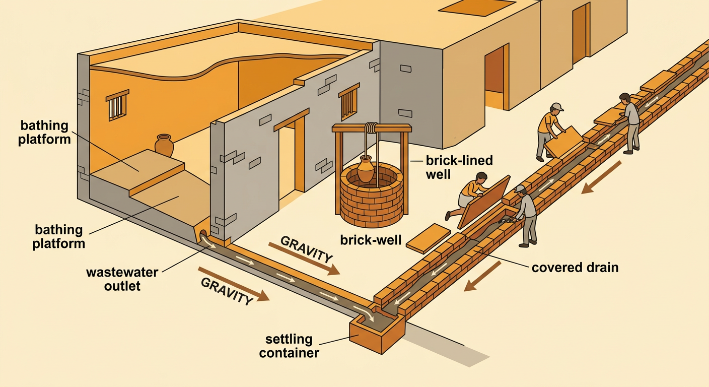
Water systems were an important part of Mohenjo-Daro’s design. Archaeologists have found many brick-lined wells, bathing platforms inside some houses, and drains that carried used water away from buildings. Some street drains were built with brick walls and removable covers so they could be inspected or cleaned. Small settling areas or containers could catch solid material before water entered a larger drain. For example, water from a household bathing floor could flow through an opening into a covered drain along the street. This system addressed a design problem: residents needed access to water while limiting standing wastewater in crowded neighborhoods. Builders had to work within constraints such as gravity, available space, brick materials, and regular maintenance. These features suggest that cleanliness and reliable water access mattered, although archaeologists cannot assume that the system worked equally well for every resident.
Clues About Government and Society
City planning offers clues about Mohenjo-Daro’s government and society, but the clues allow more than one interpretation. Standard brick proportions, coordinated streets, and connected drains suggest shared rules and organized labor. Building and maintaining these systems may have required people to plan work, gather materials, and cooperate across neighborhoods. However, archaeologists have not identified a definite royal palace, ruler’s tomb, or written law code at the site. Therefore, the evidence does not prove that a powerful king directed the city. Differences among homes also provide social clues. Some houses were large and had private wells or bathing spaces, while others were smaller and relied more on shared facilities. This may indicate differences in wealth or status. Historians must separate observation from interpretation: a large house is observable evidence, while identifying its owner as a government official would be an unsupported guess.

Making Evidence-Based Conclusions
A strong historical conclusion connects a claim to several pieces of evidence and explains the reasoning. Begin with a question, such as, “What did Mohenjo-Daro’s residents value when planning their city?” One possible claim is that residents valued organized movement and water management. Supporting evidence includes straight streets, neighborhood blocks, numerous wells, bathing areas, and covered drains. The reasoning is that these features required planning, construction skills, and continued maintenance across many locations. Students should also state limits. For example, drains show concern with moving wastewater, but they do not prove that every home had equal access or that disease was fully controlled. Maps help show patterns, while artifacts and building remains add detail. By comparing these sources, students can form a conclusion that is supported rather than imagined and revise it when new archaeological evidence becomes available.