
Native Nations Before European Colonization: Environment, Culture, and Diversity
Students use maps and historical evidence to compare how diverse Native nations developed communities, economies, and cultural practices within different North American environments before European colonization.

Illustrations are auto-generated and may be placeholders. They can be refreshed to match the narration.
North America Before European Colonization
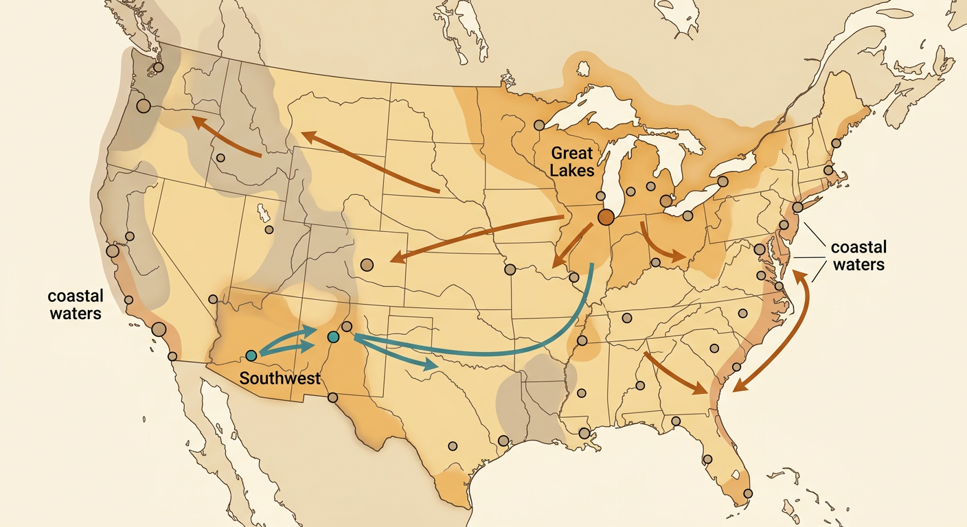
Before sustained European colonization, North America was home to millions of Indigenous people belonging to hundreds of distinct nations and language communities. Their homelands stretched from Arctic tundra to tropical forests and included cities, villages, farms, fishing grounds, and seasonal camps. Communities maintained governments, trade networks, diplomatic relationships, and systems of knowledge. Long-distance exchange connected distant regions. For example, copper from the Great Lakes, shells from coastal waters, and turquoise from the Southwest traveled through trade routes across the continent. A historical map can show the approximate locations of Native homelands, but its borders should not be read like modern state lines. Territories sometimes overlapped, shifted over time, or were shared for hunting, gathering, trade, and ceremonies.
Climate and Geographic Regions
North American climates are shaped by latitude, landforms, prevailing winds, and ocean circulation. The Pacific Ocean helps keep the Northwest Coast relatively mild and wet because winds carry moist ocean air inland. When that air rises over coastal mountains, it cools and releases rain; areas beyond the mountains are often drier because of the rain-shadow effect. In the Southwest, limited rainfall and high evaporation produce deserts and dry grasslands. Farther north, low sunlight and cold Arctic air support tundra. Ocean currents also move heat: warm currents raise nearby air temperatures, while cold currents cool coastal air. Native nations developed detailed knowledge of these regional patterns. For example, Pueblo communities in the Southwest used water-conserving farming methods suited to dry conditions and irregular rainfall.

Diverse Native Nations and Cultures
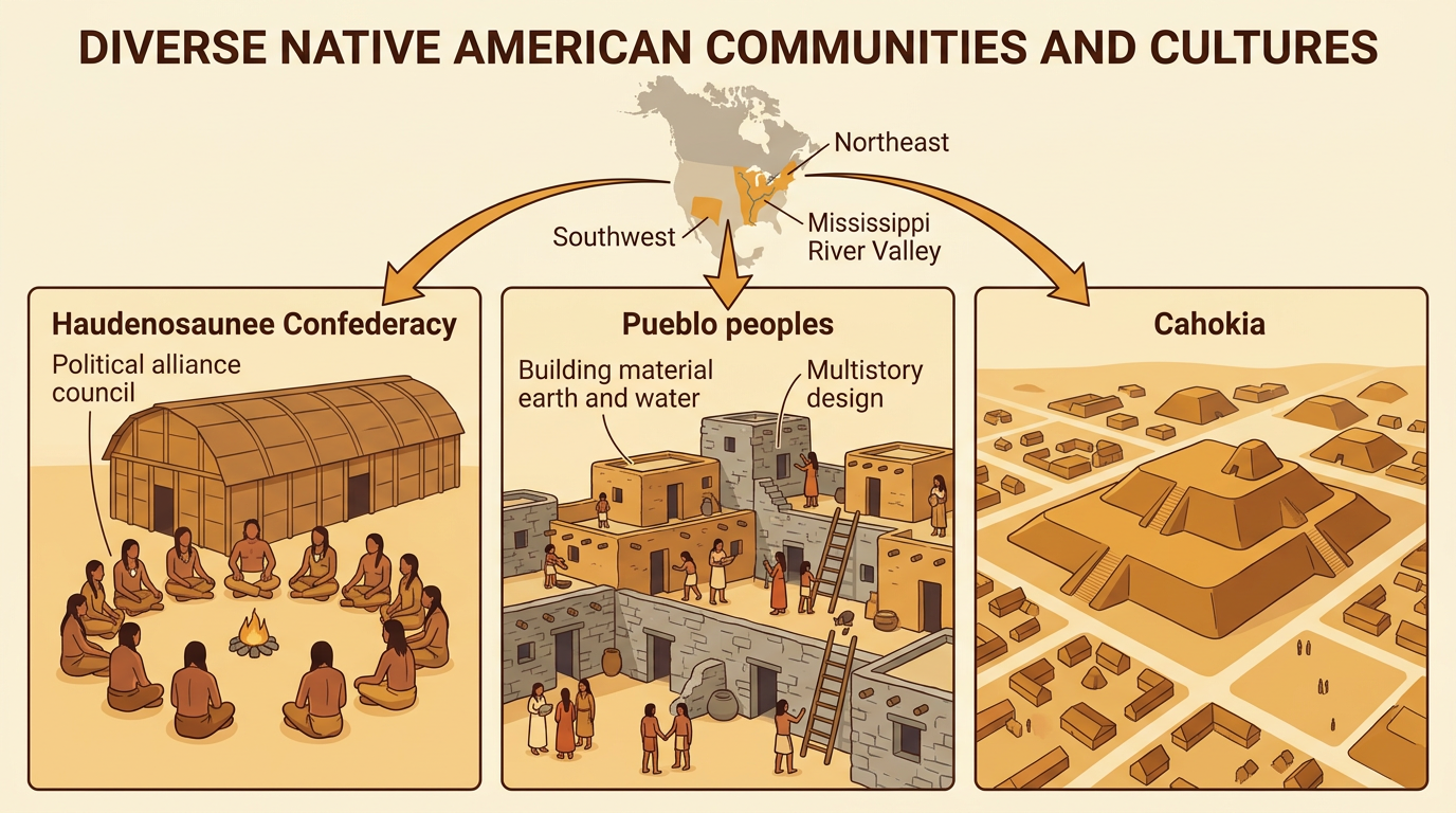
Native peoples did not share one culture or one way of life. Each nation developed its own language, government, beliefs, arts, and relationships with neighboring peoples and local environments. In the Northeast, the Haudenosaunee Confederacy united several nations through a shared political alliance while each nation kept its own identity and council. In the Southwest, Pueblo peoples built multistory communities from stone and adobe and practiced farming in dry environments. Near the Mississippi River, Cahokia became a large urban center with public plazas, neighborhoods, and monumental earthen mounds. These examples represent only part of the continent's diversity. Cultures were also dynamic: communities adopted new crops, exchanged ideas, migrated, formed alliances, and responded to environmental and political changes over many generations.
Resources, Economies, and Land Use
Native economies combined farming, hunting, fishing, gathering, manufacturing, and trade in different ways. Economic choices depended partly on available resources, but people actively managed their environments rather than simply adapting to them. Many Eastern Woodlands communities grew corn, beans, and squash together; the crops supplied complementary nutrients and used growing space efficiently. On the Northwest Coast, nations developed technologies and seasonal practices for harvesting and preserving salmon. Some communities used controlled burns to encourage useful plants, improve wildlife habitat, and keep travel areas open. Plains peoples hunted bison and used meat, hides, bones, and sinew for food and tools. These practices changed landscapes, but they were often guided by careful observation, seasonal timing, community rules, and responsibilities to protect resources for future use.

Comparing Regional Communities
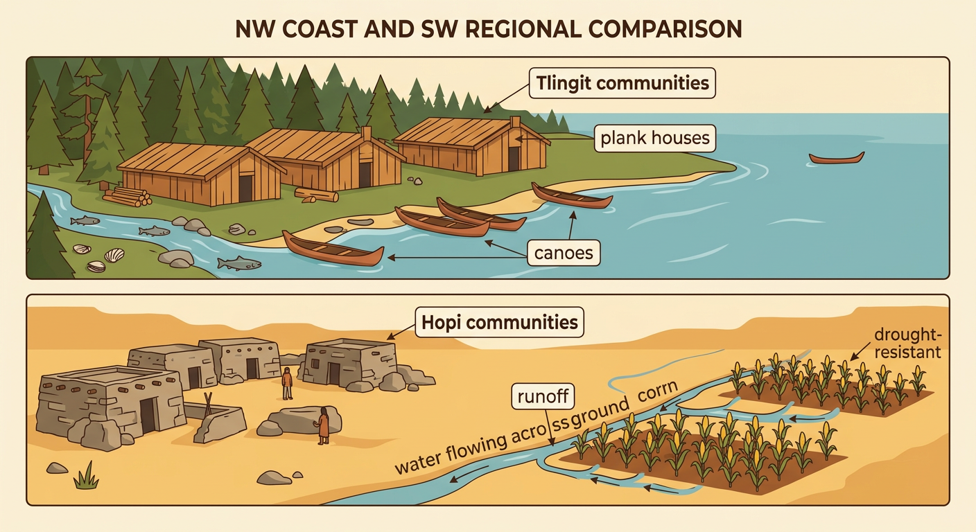
Comparing communities shows how both environment and culture influenced daily life. Along the Northwest Coast, abundant salmon, shellfish, cedar, and other forest resources supported permanent villages and skilled woodworking. Tlingit communities, for example, built large plank houses and crafted canoes for coastal travel, fishing, and exchange. In the dry Southwest, Hopi communities relied more heavily on drought-resistant farming and carefully selected planting locations where limited runoff could reach crops. They built compact villages using local stone and earth. Geography helped shape these choices, but it did not determine them completely. Knowledge, beliefs, political decisions, technology, and trade also mattered. Both regions supported permanent communities and complex social systems, even though their food sources, building materials, transportation, and water-management practices differed.
Challenging Myths with Evidence
Evidence challenges the myth that North America was an empty wilderness or that all Native peoples lived in the same way. Archaeological remains, oral histories, maps, artifacts, architecture, and environmental evidence reveal large populations and carefully managed landscapes. At Cahokia, the size of Monks Mound, the arrangement of plazas, and remains of houses show that people planned and maintained a major urban center by about 1050 CE. Pollen, charcoal, animal bones, and plant remains can help researchers reconstruct farming, burning, hunting, and climate patterns. Native oral traditions provide knowledge about homelands, migrations, relationships, and important events. Each source has limits, so historians compare several forms of evidence and consider who created or interpreted them. Strong conclusions come from evidence, not stereotypes or unsupported assumptions.
