
Reducing the Impacts of Natural Hazards
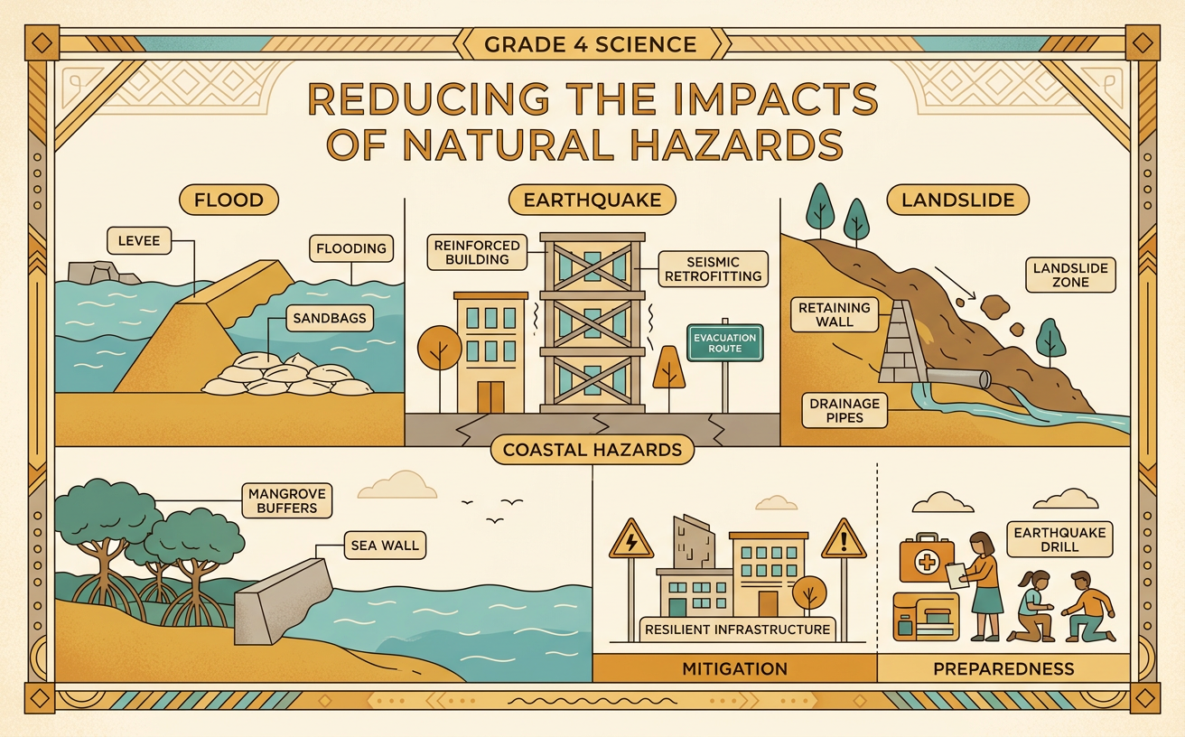
Students compare ways that communities can reduce harm from floods, earthquakes, landslides, and other natural Earth processes.
Illustrations are auto-generated and may be placeholders. They can be refreshed to match the narration.
Natural Processes and Hazards
Earth is always changing. Rain fills rivers, tectonic plates move, wind pushes ocean water, and gravity pulls soil downhill. These natural processes become hazards when they can harm people, buildings, roads, or other parts of a community. Heavy rain may cause a river to flood nearby land. Movement along a fault may cause an earthquake. Water-soaked soil on a steep slope may slide downhill as a landslide. A hazard is not the same as a disaster. An earthquake in an empty area may cause little damage, while the same-sized earthquake beneath a crowded city may be disastrous. Scientists study where hazards have happened and how often they occur. Communities use this information to identify risky locations and prepare before the next event.

How Hazards Affect Communities
Natural hazards can change where and how people live. A flood may damage homes, contaminate drinking water, close schools, and wash out roads. An earthquake can break bridges, water pipes, and power lines. A landslide may bury a road or make a hillside unsafe for houses. These effects can separate families from jobs, stores, hospitals, and one another. Some people return and rebuild after the danger passes. Others move temporarily or migrate to a safer settlement. For example, repeated flooding in a riverside neighborhood may lead families to move to higher ground. The amount of harm depends on the hazard, the location, the strength of buildings, and how well the community prepared. Emergency plans and warning systems can also reduce injuries and help people recover more quickly.

Engineering Solutions
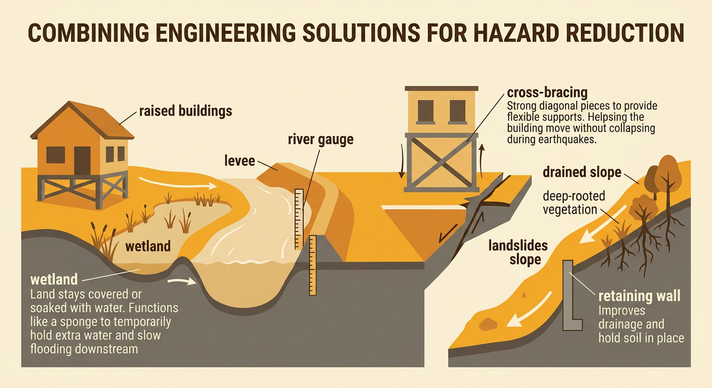
Engineers design solutions that reduce damage, but no solution can stop every natural process. For floods, communities may build levees, create rain gardens, restore wetlands, or raise buildings above expected flood levels. For earthquakes, builders can add flexible supports, strong connections, and cross-bracing so structures move without collapsing. For landslides, workers may improve drainage, plant deep-rooted vegetation, build retaining walls, or avoid construction on unstable slopes. Warning systems are another solution. River gauges can trigger flood alerts, and earthquake sensors can provide a few seconds of warning in some locations. For example, a town might restore a wetland beside a river. The wetland can temporarily hold extra water, reducing the height and speed of floodwater downstream. Engineers test ideas, use evidence, and often combine several solutions to protect a community.
Comparing Costs and Benefits
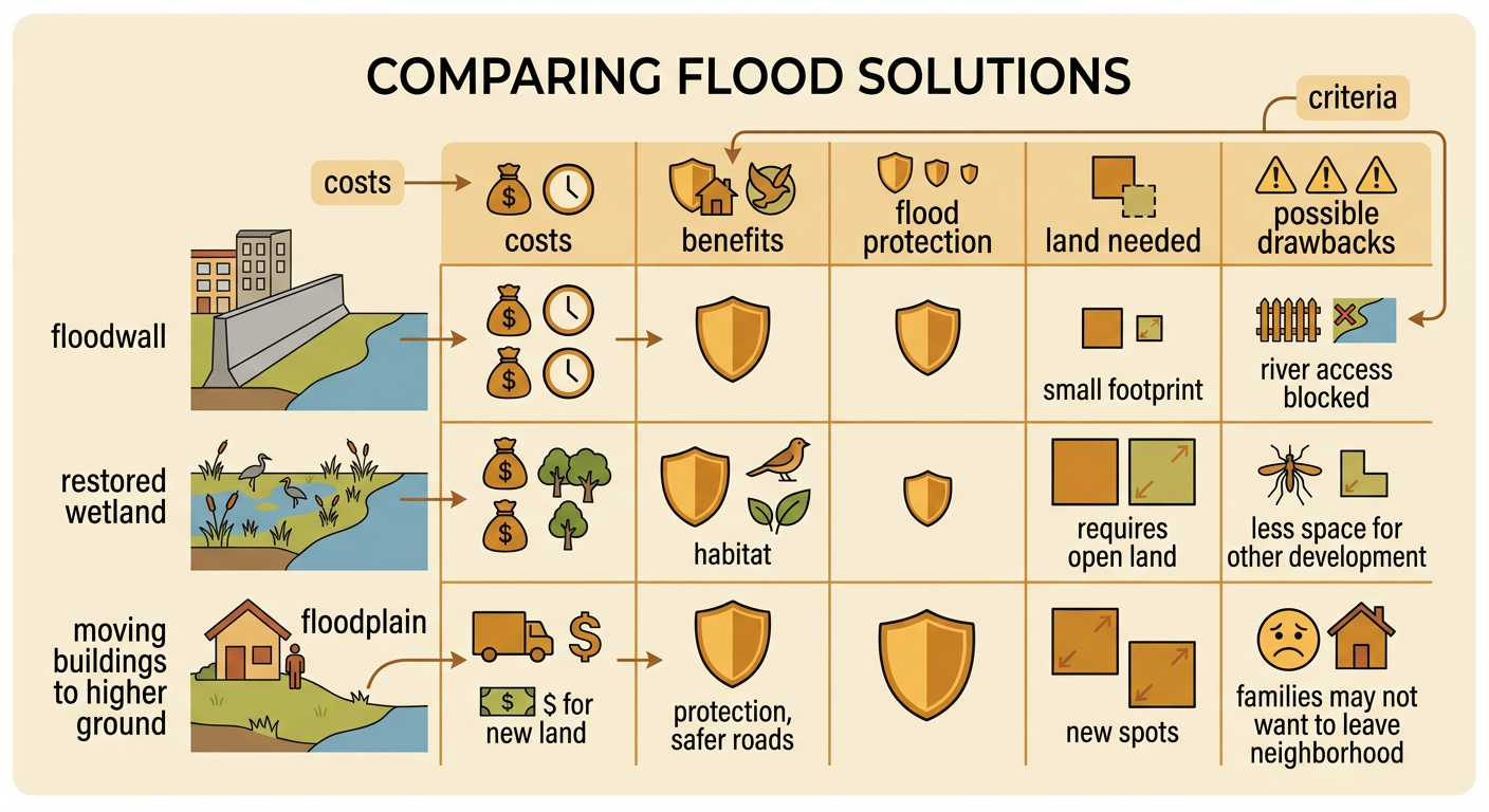
Every safety solution has costs and benefits. Costs can include money, construction time, maintenance, land use, and effects on plants, animals, or neighborhoods. Benefits include fewer injuries, less property damage, safer roads, and faster recovery. A concrete floodwall may protect many buildings, but it can be expensive and may block access to the river. Restoring a wetland may store floodwater and provide wildlife habitat, but it requires enough open land. Moving homes away from a floodplain can greatly reduce future risk, but families may not want to leave their neighborhood. Communities should compare solutions using the same criteria. They can ask how much each choice reduces risk, how long it lasts, who benefits, and what problems it might create. The best choice may be a combination rather than one solution.
Recommend a Safety Solution
A strong recommendation states an opinion and supports it with reasons and information. First, identify the hazard and the people or places at risk. Next, compare at least two possible solutions. Then choose one solution, or a combination, and explain why its benefits outweigh its costs. For example, a student might write, “Our town should restore the wetland and raise the lowest homes because both actions reduce flood damage.” The student could support this opinion by explaining that wetlands hold extra water while elevated homes keep living spaces above many floods. The student should also recognize limits: the plan needs land and money, and extreme floods may still cause damage. Finally, include evidence from maps, hazard records, models, or reliable sources. A clear conclusion should restate the recommendation and its most important reason.
