Seeing the World Through the Five Themes of Geography
Students use maps and a brief place-based case study to examine location, place, human-environment interaction, movement, and region as connected tools geographers use to investigate the world.
Illustrations are auto-generated and may be placeholders. They can be refreshed to match the narration.
Think Like a Geographer
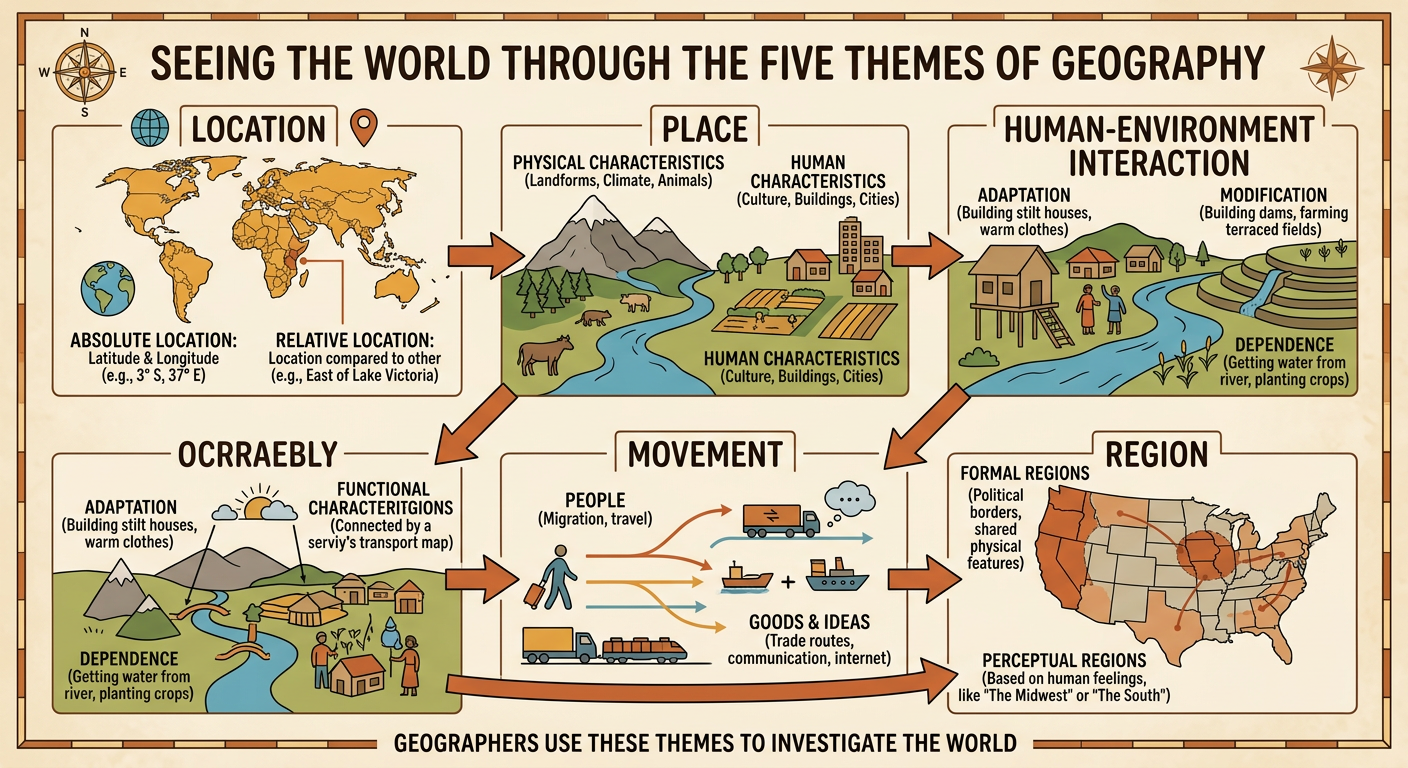
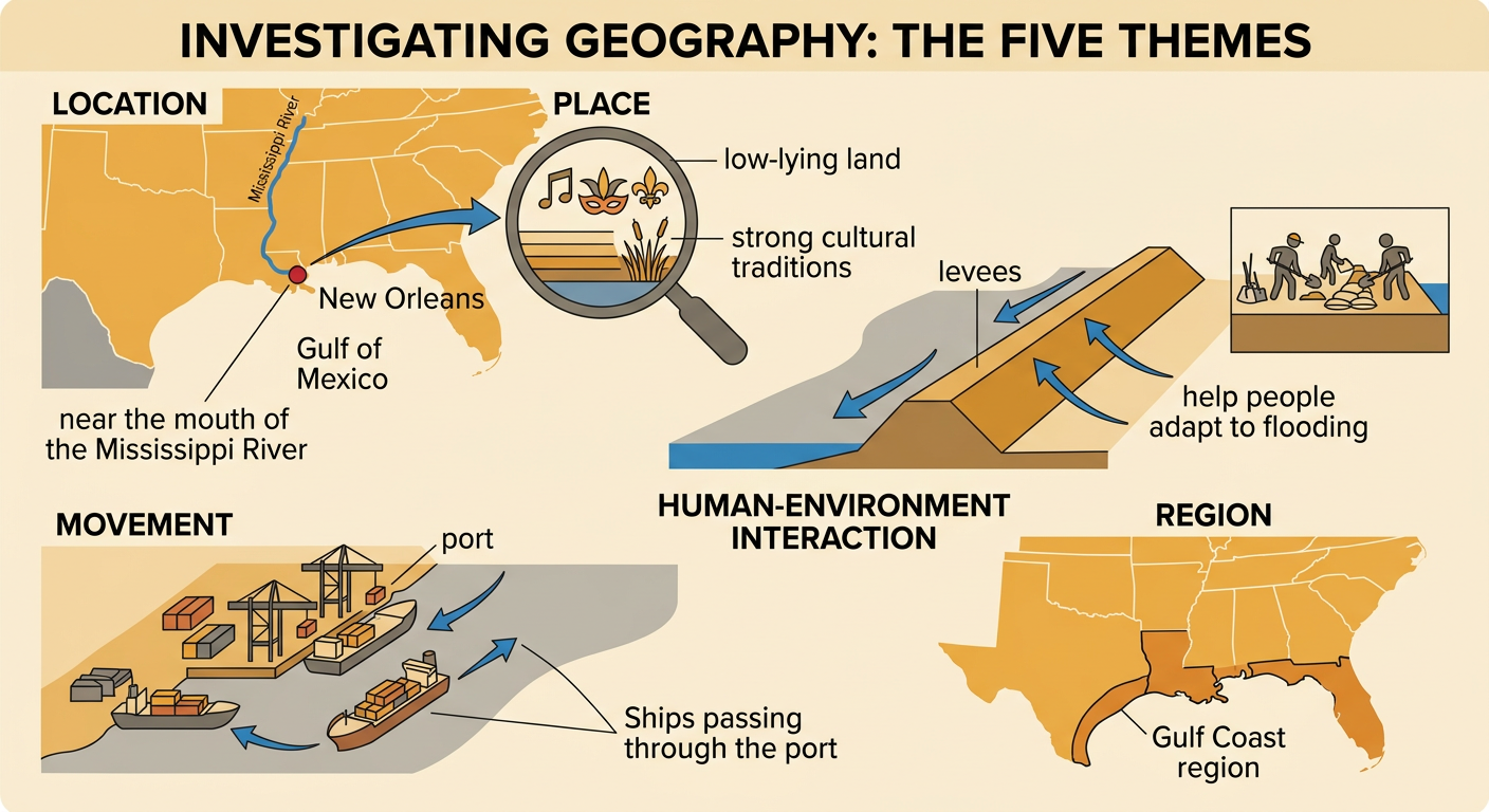
Geographers investigate where things are, why they are there, and how people and environments are connected. The five themes of geography are location, place, human-environment interaction, movement, and region. Each theme provides a different lens, but geographers often use several at once. For example, a geographer studying New Orleans might identify its location near the mouth of the Mississippi River, describe its low-lying land and cultural traditions, and examine how levees help people adapt to flooding. The geographer could also study the movement of ships through the port and classify the city as part of the Gulf Coast region. Maps provide spatial evidence, while photographs, population data, and written sources add details. Comparing these sources helps geographers form explanations supported by evidence rather than guesses.
Location: Absolute and Relative Position
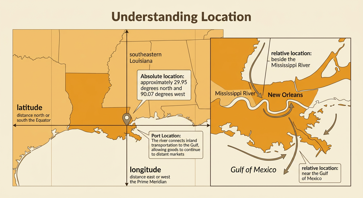
Location tells where a place is. Absolute location identifies one exact position, often with latitude and longitude. Lines of latitude measure distance north or south of the Equator, while lines of longitude measure distance east or west of the Prime Meridian. New Orleans has an approximate absolute location of 29.95° N, 90.07° W. Relative location explains where a place is compared with other features. New Orleans is in southeastern Louisiana, beside the Mississippi River and near the Gulf of Mexico. Relative descriptions may include direction, distance, travel time, or nearby landmarks. Absolute location is useful for plotting a precise point, while relative location helps explain connections. New Orleans developed as a port partly because its relative location links the river’s inland transportation network to the Gulf of Mexico.
Place: Human and Physical Characteristics
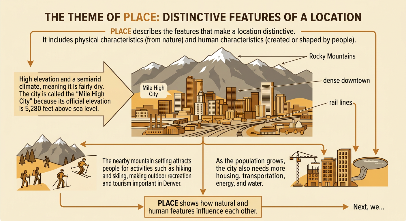
Place describes the characteristics that make a location distinctive. Physical characteristics are natural features such as landforms, climate, waterways, soil, plants, and wildlife. Human characteristics are created or shaped by people, including buildings, languages, roads, governments, and traditions. Denver, Colorado, provides a clear example. Its physical setting includes high elevation, a semiarid climate, and a position just east of the Rocky Mountains. The city is commonly called the Mile High City because its official elevation is one mile, or 5,280 feet, above sea level. Denver’s human characteristics include a dense downtown, neighborhoods, highways, parks, and rail lines. Physical and human characteristics can influence each other. Denver’s mountain setting supports tourism and outdoor recreation, while its growing population has increased the need for housing, transportation, energy, and water.
Human-Environment Interaction
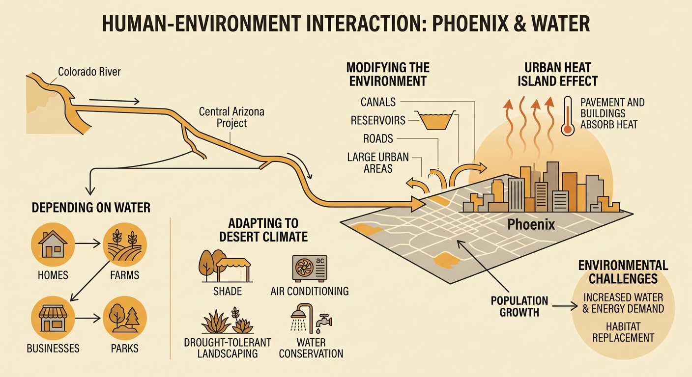
Human-environment interaction examines how people depend on, adapt to, and modify the natural world. Phoenix, Arizona, depends on water for homes, farms, businesses, and parks, even though it has a hot desert climate with limited rainfall. People adapt by using shade, air conditioning, drought-tolerant landscaping, and water conservation. They modify the environment by building reservoirs, canals, roads, and large urban areas. Some Colorado River water reaches central Arizona through the Central Arizona Project canal system. Population growth can increase demand for water and energy. It can also replace desert habitat with pavement and buildings, which absorb heat and contribute to the urban heat island effect. An evidence-based argument about Phoenix should connect population or resource-use data to measured environmental effects, while also considering conservation programs and other possible solutions.
Movement of People, Goods, and Ideas
Movement explains how people, goods, and ideas travel between places. Transportation routes, communication systems, jobs, trade, and migration create connections across short and long distances. Chicago became a major transportation center because it lies beside Lake Michigan and connects waterways, railroads, highways, and air routes. Grain and other goods move into the city from surrounding areas and then travel to markets elsewhere. People move through Chicago for work, education, tourism, or migration. Ideas also move through books, news, music, schools, and digital networks. These flows can change both the place where movement begins and the place where it ends. A transportation map can reveal Chicago’s connections, but written information helps explain what moves, why it moves, and how that movement affects jobs, cultures, traffic, and resource use.

Regions and Five-Theme Case Study
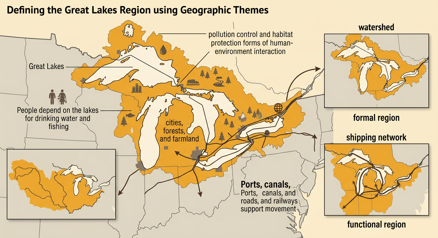
A region is an area grouped by shared characteristics or connections. A formal region shares a measurable feature, such as climate or government boundaries. A functional region is organized around a central activity or network. A perceptual region is based on how people understand or imagine an area. The Great Lakes provide a five-theme case study. Their location is along the United States–Canada border. Their place characteristics include five large freshwater lakes, major cities, forests, and farmland. Human-environment interaction includes drinking-water use, fishing, shoreline development, pollution control, and habitat protection. Movement occurs through ports, canals, roads, and railways that carry people and goods. The Great Lakes region can be mapped as a formal physical region using its watershed or as a functional region using its shipping network. Together, the five themes explain why the lakes are environmentally and economically important.