
The Aral Sea Crisis: Policy, Environment, and Human Consequences
Students analyze maps, data, and firsthand accounts to explain how Soviet irrigation policies transformed the Aral Sea and affected communities across Central Asia.

Illustrations are auto-generated and may be placeholders. They can be refreshed to match the narration.
The Aral Sea Before Large-Scale Irrigation
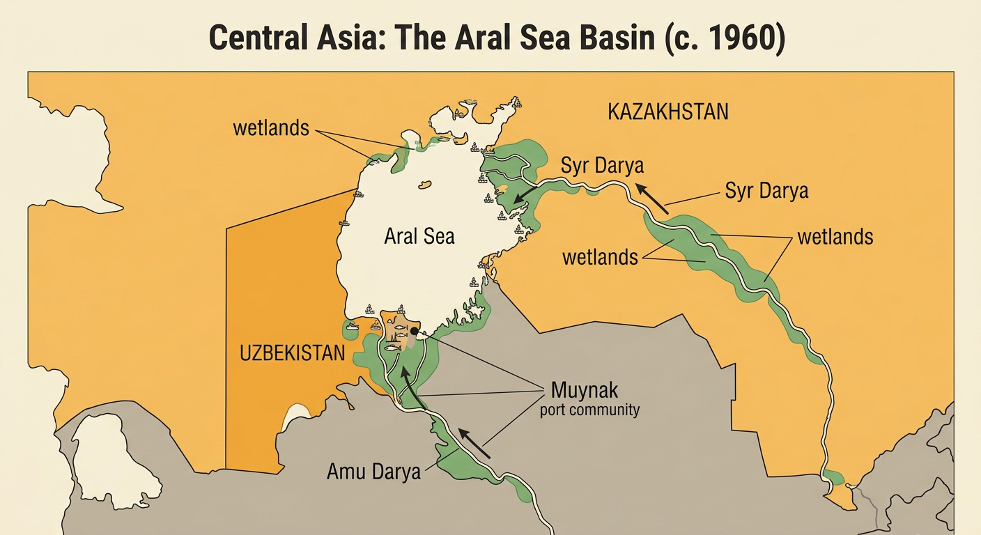
Before the 1960s, the Aral Sea was one of the world’s largest inland bodies of water. Located between present-day Kazakhstan and Uzbekistan, it was fed mainly by two rivers: the Syr Darya from the northeast and the Amu Darya from the south. Because the sea had no outlet to an ocean, river inflow helped balance water lost through evaporation. The surrounding region included wetlands, river deltas, fishing settlements, and grazing areas. Commercial fisheries supplied jobs and food throughout the Soviet Union. For example, Muynak, now far from the shoreline, was once a busy Uzbek port with fish-processing plants. Although the sea’s water was somewhat salty, many fish species could survive there. This geography shows why changes to the two rivers could transform both the sea and the communities that depended on it.
Soviet Agricultural Goals and Water Diversion
Soviet leaders sought to increase agricultural production in Central Asia, especially cotton, a valuable crop used by textile industries. Beginning on a massive scale in the 1960s, government planners expanded canals that diverted water from the Amu Darya and Syr Darya to irrigate dry land. The Karakum Canal, for example, carried Amu Darya water across Turkmenistan. Many canals were unlined, so water seeped into the ground or evaporated before reaching fields. Cotton production increased, but much less river water reached the Aral Sea. The policy treated water as a resource for meeting state production targets while giving limited attention to long-term environmental costs. This was both a political and economic decision: central authorities selected crops, controlled water infrastructure, and rewarded high output. The resulting decline of river inflow caused the sea to shrink and become saltier.

Reading Maps and Environmental Data
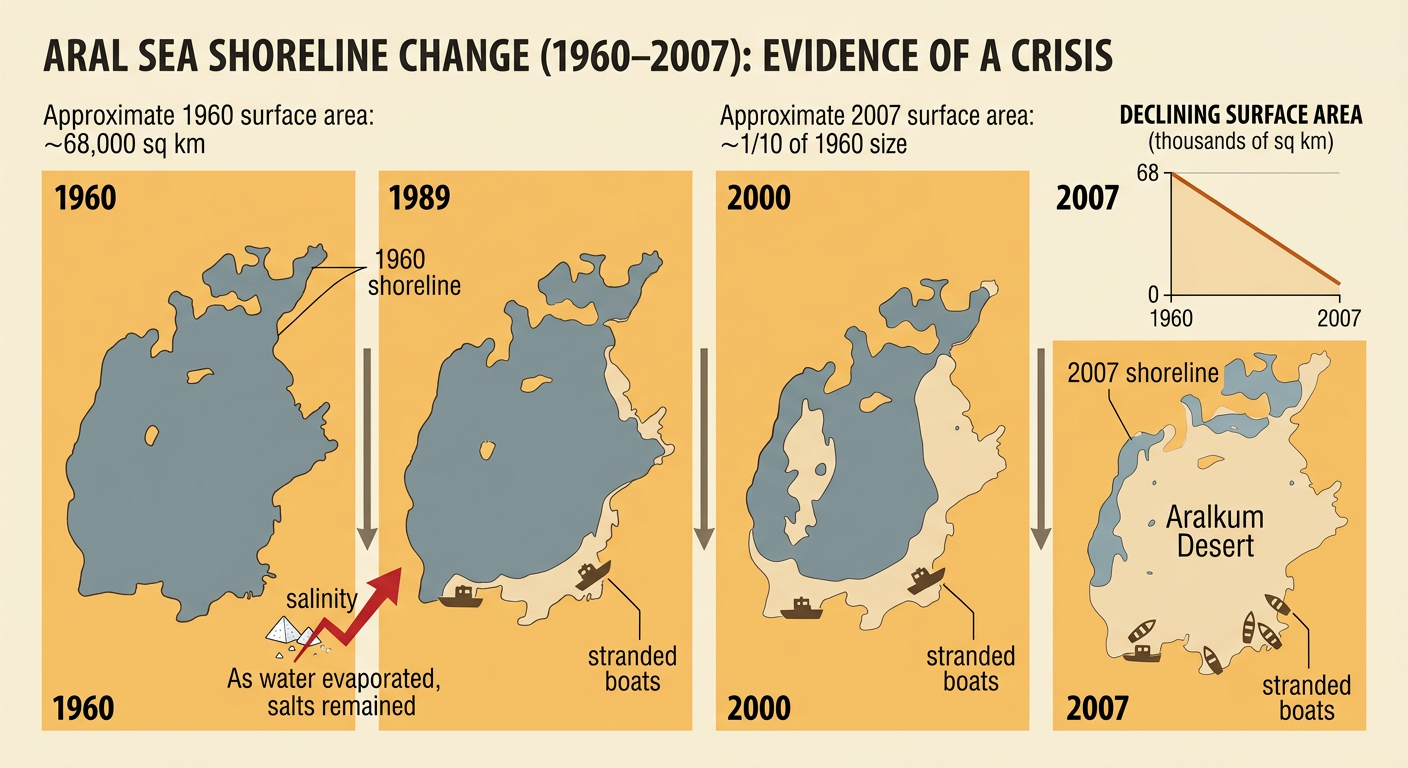
Historical maps and measurements reveal the speed and scale of the crisis. Around 1960, the Aral Sea covered approximately 68,000 square kilometers. By 2007, it had declined to about one-tenth of its earlier area and had separated into several water bodies. As water volume fell, salinity rose because salts remained behind during evaporation. Satellite images also show newly exposed lakebed, much of which became the Aralkum Desert. To analyze this evidence, students should compare maps made at the same scale, identify the dates, and connect changes in area with data on river flow and salinity. A firsthand account from a former fisher describing boats stranded on sand adds qualitative evidence. Used together, numerical data explain how much change occurred, while personal testimony shows what the change meant to people living there.
Economic, Health, and Social Consequences
The shrinking sea changed work, health, and daily life across the region. Rising salinity destroyed most of the commercial fish population, and the fishing industry had largely collapsed by the 1980s. Ports such as Muynak were left many miles from open water, causing unemployment and migration. Winds carried salt and dust from the exposed lakebed onto farms and settlements. Some sediments contained agricultural chemicals that had washed into the sea, creating additional concerns about contaminated dust and soil. Regional communities experienced high rates of respiratory illness, anemia, and other health problems, although researchers caution that poverty, limited medical care, poor nutrition, and unsafe water also contributed. Cultural traditions connected to fishing and coastal life weakened as families moved or changed occupations. The crisis therefore demonstrates how an environmental change can produce connected economic, health, social, and cultural consequences.

Evaluating Restoration and Policy Responses
Restoration efforts show that technological solutions can help, but they involve tradeoffs. In 2005, Kazakhstan completed the Kok-Aral Dam, separating the North Aral Sea from the larger southern basins. The dam helped retain water delivered by the Syr Darya. Water levels in the North Aral rose, salinity declined, and several fish species and commercial fishing activities returned. However, the dam did not restore the entire sea, and much of the South Aral continued to shrink because water diversion remained extensive. Policymakers can also improve irrigation efficiency, repair or line canals, shift away from highly water-demanding crops, restore delta wetlands, and coordinate water use among Central Asian countries. Students should evaluate each response by comparing cost, water savings, effects on farmers, ecosystem recovery, and fairness between upstream and downstream communities. A successful policy must reduce environmental harm without ignoring livelihoods and food or export needs.
