The Louisiana Purchase: A Nation Doubles in Size
Students use historical accounts, maps, and numerical data to examine why the United States purchased the Louisiana Territory and how the purchase changed the nation.
Illustrations are auto-generated and may be placeholders. They can be refreshed to match the narration.
The United States Before 1803
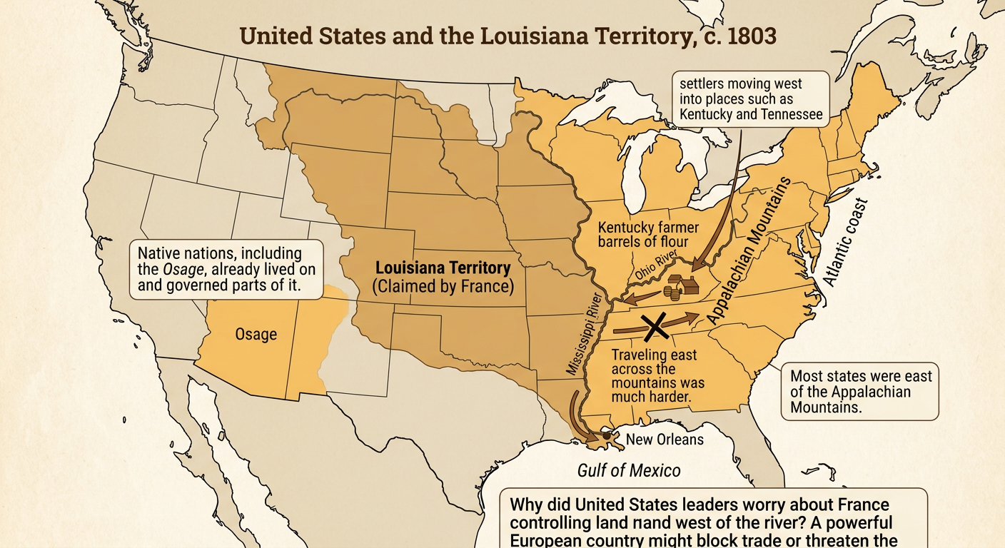
Before 1803, the United States stretched from the Atlantic coast to the Mississippi River. Most states were east of the Appalachian Mountains, but settlers were moving west into places such as Kentucky and Tennessee. West of the Mississippi lay the enormous Louisiana Territory, claimed by France after Spain agreed to return it. Many Native nations, including the Osage, lived on and governed parts of this land. Rivers connected western farms to distant markets. For example, a Kentucky farmer could send barrels of flour down the Ohio River and then the Mississippi River toward New Orleans. Mountains made travel east difficult, so western settlers depended on these waterways. United States leaders worried that a powerful European country controlling the land west of the Mississippi could limit trade and threaten national security.
Why New Orleans Mattered
New Orleans stood near the mouth of the Mississippi River, where the river meets the Gulf of Mexico. Goods from farms in the Ohio and Mississippi river valleys traveled downstream to the city. At New Orleans, workers transferred products such as flour, tobacco, and pork onto ships that could cross the Gulf or sail to Atlantic ports. A 1795 agreement with Spain gave Americans a right of deposit, allowing them to store goods in New Orleans before shipment. In 1802, Spanish officials temporarily ended that right. This alarmed farmers and merchants. For example, if a farmer’s flour reached New Orleans but could not be stored or loaded onto a ship, the farmer might lose both the flour and the money expected from its sale. Control of New Orleans therefore affected trade throughout the growing western settlements.

Jefferson's Decision to Purchase
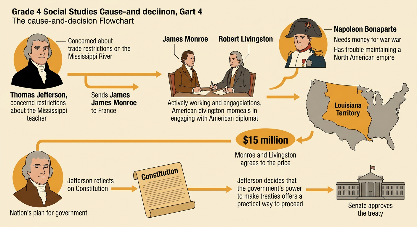
President Thomas Jefferson wanted to protect American trade by gaining New Orleans. He sent James Monroe to join diplomat Robert Livingston in France and negotiate. France’s leader, Napoleon Bonaparte, needed money for war and faced difficulties maintaining a North American empire. He offered to sell the entire Louisiana Territory rather than only New Orleans. Monroe and Livingston agreed to a price of $15 million in 1803. Jefferson believed the purchase would help farmers and make the nation more secure, but he wondered whether the Constitution clearly gave a president power to acquire territory. He decided that the treaty-making power provided a practical way to act. The United States Senate approved the treaty. This sequence shows how trade concerns, France’s needs, diplomatic negotiations, and government action combined to produce the purchase.
Mapping the New Territory
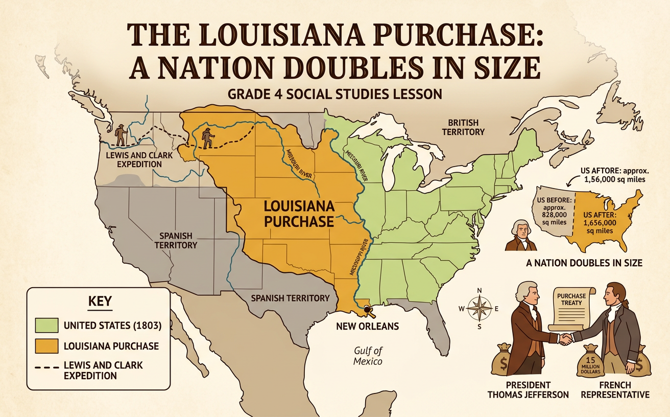
The Louisiana Purchase added land west of the Mississippi River and east of the Rocky Mountains. It extended from the Gulf of Mexico north toward the border with British North America, although some boundaries were disputed. The territory included broad grasslands, forests, rivers, and parts of major mountain systems. A physical map reveals a pattern: many rivers begin in higher western areas and flow east or southeast toward the Mississippi River. The Missouri River, for example, crosses much of the territory and joins the Mississippi near present-day St. Louis. These connected waterways supported travel, trade, wildlife, and human communities. The land was not empty. Numerous Native nations already lived there and had their own governments and trade networks. Comparing political and physical maps helps students see both claimed boundaries and natural features.

The Purchase by the Numbers
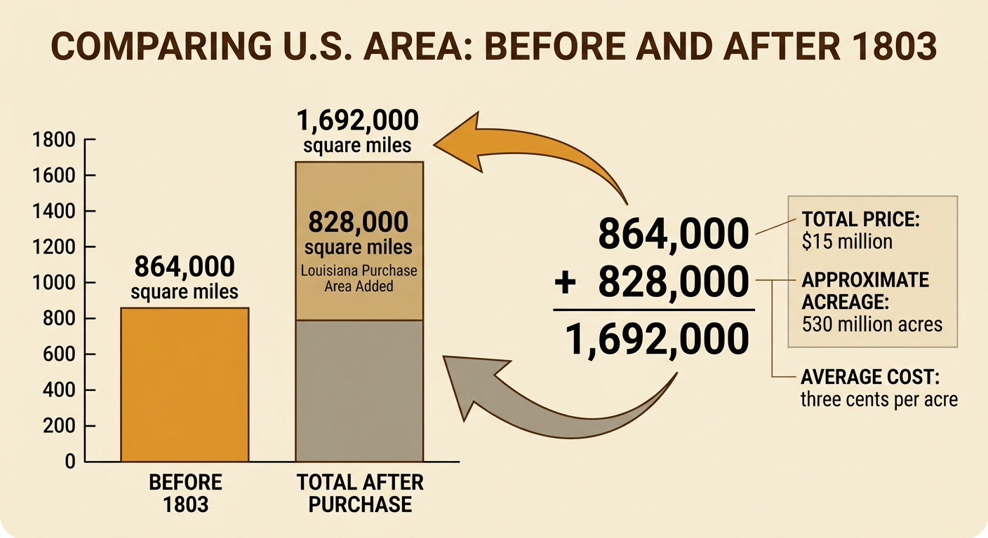
The United States paid France $15 million for approximately 828,000 square miles of land. Historical measurements vary slightly, so these figures are estimates. The country had covered about 864,000 square miles before the purchase. Adding the numbers shows the change: 864,000 + 828,000 = 1,692,000 square miles. The purchase therefore nearly doubled the nation’s claimed area. Subtraction checks the result: 1,692,000 − 864,000 = 828,000. The territory contained about 530 million acres, making the average price close to three cents per acre. That average does not mean each acre was separately priced or sold. The treaty transferred France’s claim to the United States, while Native nations continued to live on and govern much of the land. Numerical evidence helps explain why leaders considered the agreement unusually large and important.
Causes and Lasting Effects
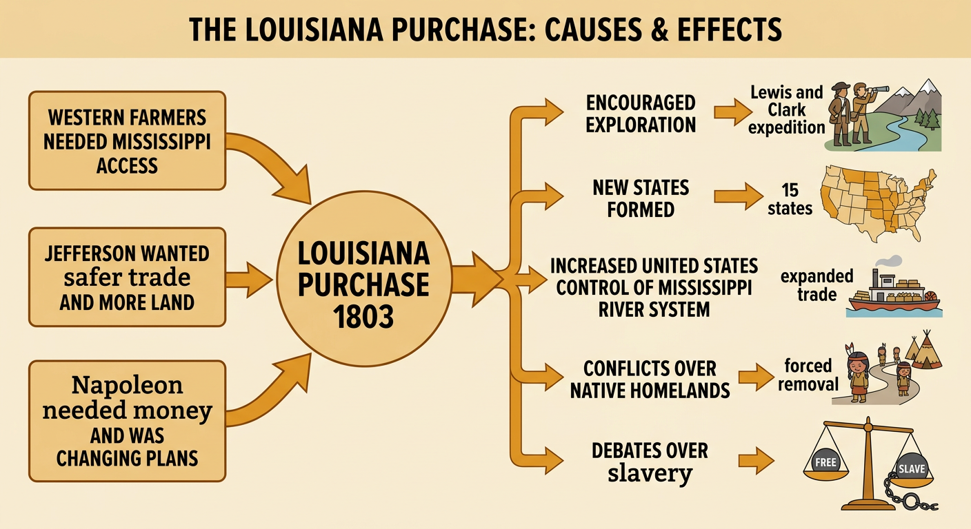
The Louisiana Purchase had several connected causes. Western farmers needed dependable access to the Mississippi River and New Orleans. Jefferson wanted safer trade and more land for the growing nation. Napoleon needed money and was reconsidering France’s plans in North America. Together, these conditions made an agreement likely. The effects lasted far beyond 1803. The purchase encouraged exploration, including the Lewis and Clark expedition, and eventually contributed land to all or part of 15 states. It strengthened westward migration and increased United States control of the Mississippi River system. However, expansion also brought serious conflict. Native nations faced broken agreements, pressure to give up homelands, and forced removal. As new territories sought statehood, Americans also argued over whether slavery would expand westward. A complete historical explanation connects the purchase to both national growth and harmful consequences for people already living on the land.