The Panama Canal: Engineering, Disease, and American Power
Students examine how geography, engineering, disease control, labor, and U.S. foreign policy shaped the construction and consequences of the Panama Canal.
Illustrations are auto-generated and may be placeholders. They can be refreshed to match the narration.
Why Build a Canal?
Before 1914, ships traveling between the Atlantic and Pacific Oceans usually had to sail around Cape Horn at the southern tip of South America. This route was long, costly, and dangerous. A canal across the narrow Isthmus of Panama promised faster movement of goods, people, and warships. For example, the canal shortened the sea route between New York and San Francisco from about 13,000 miles to roughly 5,200 miles. The Spanish-American War of 1898 also demonstrated the military value of a shortcut when the battleship USS Oregon made a lengthy voyage around South America to reach the Caribbean. Business leaders expected lower shipping costs, while U.S. officials wanted greater naval mobility and influence. Economic competition, military strategy, and Panama’s geography therefore combined to create strong support for a canal.

Geography and Engineering Challenges
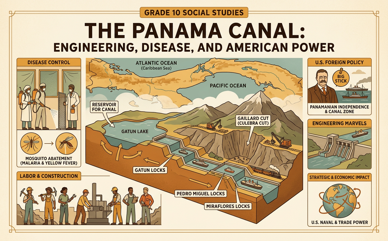
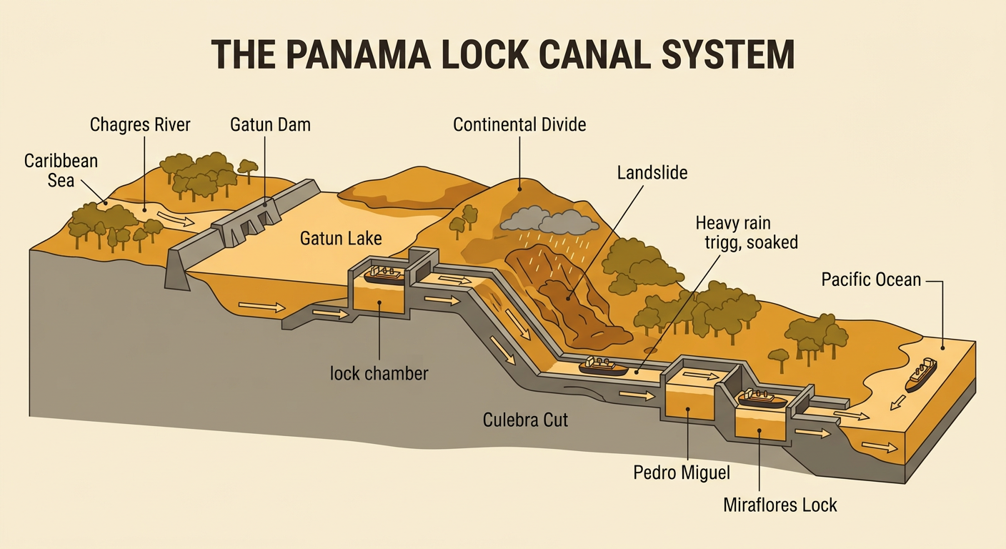
Panama’s geography made a canal possible, but it also made construction difficult. The route crossed tropical forests, the flood-prone Chagres River, and the hills of the Continental Divide. Heavy rainfall soaked exposed soil and helped cause deadly landslides in the Culebra Cut. Engineers chose a lock canal rather than digging the entire route to sea level. Gatun Dam blocked the Chagres River and created Gatun Lake, which became part of the navigation channel. Locks then raised ships about 85 feet above sea level and lowered them on the other side. For example, water flowing by gravity into a lock chamber lifts a ship when the gates are closed. This system used local water and terrain to solve an engineering problem, but it also required constant dredging, slope stabilization, and careful management of freshwater supplies.
Disease Control and the Canal Zone
Tropical climate and disease were major obstacles to canal construction. During the French effort in the 1880s, thousands of workers died, especially from yellow fever and malaria. Many people did not yet understand that mosquitoes transmitted these diseases. Later research established that Aedes aegypti mosquitoes spread yellow fever and Anopheles mosquitoes spread malaria. Under physician William Gorgas, U.S. sanitation teams drained standing water, covered water containers, installed window screens, fumigated buildings, and placed oil on pools where mosquitoes bred. For example, removing water from discarded containers interrupted the mosquito life cycle by preventing larvae from developing. Yellow fever transmission in the Canal Zone was stopped by 1905, while malaria rates and deaths also declined substantially. Disease control made construction more successful, showing how climate, water, scientific knowledge, and organized public health measures can influence human activity.

Labor and Unequal Working Conditions
The canal depended on a large and diverse workforce. Tens of thousands of laborers came from Caribbean islands, especially Barbados, while others arrived from Europe, the United States, Panama, and nearby regions. Workers dug earth, operated machinery, laid track, built locks, and cared for the sick. Their experiences were unequal. The U.S. administration divided employees into the “gold roll” and “silver roll.” The gold roll included mostly White U.S. workers in skilled or supervisory jobs who received higher pay and better housing. The silver roll included mostly Black Caribbean and local workers who generally received lower wages and poorer services. For example, two workers contributing to the same construction system could use separate housing, dining, and recreational facilities based on racial and national classifications. Landslides, explosions, equipment accidents, heat, and disease added further risks. The canal’s success therefore rested on labor within a discriminatory system.

U.S. Intervention in Panama
The canal’s construction was tied to U.S. intervention and Panama’s separation from Colombia. In 1903, Colombia’s senate rejected the Hay-Herrán Treaty, which would have allowed the United States to build a canal across Colombian territory in Panama. Panamanian separatists then declared independence in November 1903. President Theodore Roosevelt sent U.S. naval forces to the area, limiting Colombia’s ability to respond. The United States quickly recognized Panama. Soon afterward, the Hay–Bunau-Varilla Treaty granted the United States extensive control over a Canal Zone about ten miles wide in exchange for payment and protection. The treaty was signed for Panama by Philippe Bunau-Varilla, a French citizen who had supported independence but was not elected by Panamanians. For some Panamanians, independence created a new nation; for others, the treaty showed coercion and foreign domination. Nationalism, business interests, and U.S. power all shaped the outcome.

Global Trade and Political Consequences
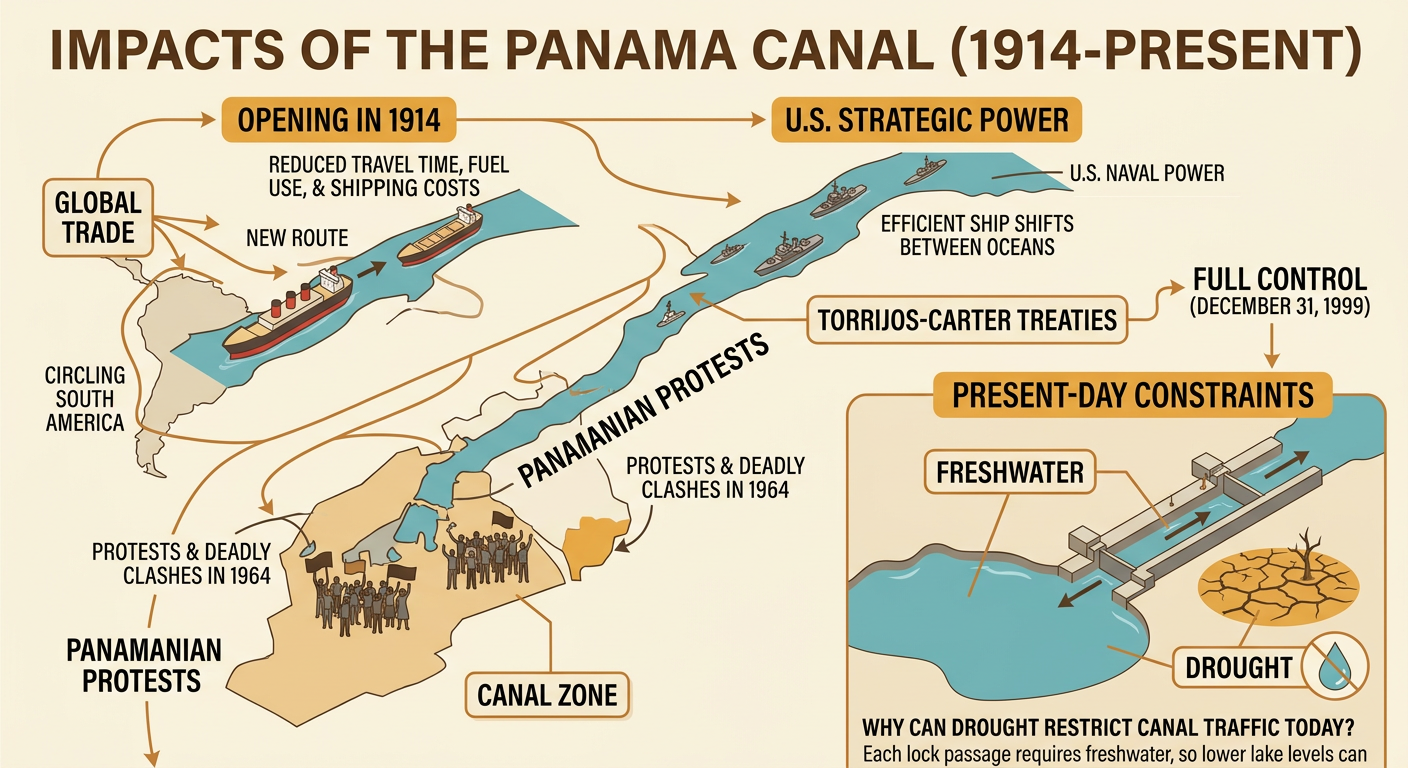
The Panama Canal opened to commercial traffic in 1914 and changed global transportation. Ships could move more quickly between Atlantic and Pacific ports, reducing some travel times, fuel use, and shipping costs. The canal also allowed the U.S. Navy to transfer vessels between oceans more efficiently, strengthening American strategic power. For example, cargo moving between the eastern United States and East Asia no longer had to circle South America. However, U.S. control of the Canal Zone caused lasting resentment in Panama. Protests and deadly clashes in 1964 increased pressure for change. The 1977 Torrijos-Carter Treaties established a process that transferred full control of the canal to Panama on December 31, 1999. The canal remains important, but it depends on freshwater stored in its watershed. Drought can lower lake levels and restrict ship traffic, linking modern global trade to climate, natural resources, engineering, and political decisions.