
The Silk Roads: Trade, Geography, and Cultural Diffusion
Students examine how geography shaped Silk Roads trade and how long-distance exchange spread goods, technologies, religions, and diseases across Afro-Eurasia.

Illustrations are auto-generated and may be placeholders. They can be refreshed to match the narration.
Mapping the Silk Roads
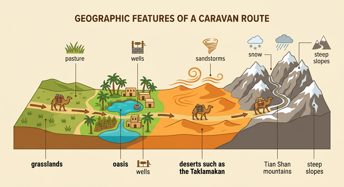
The Silk Roads were a changing network of overland and maritime routes, not one continuous road. Overland routes connected cities across East Asia, Central Asia, Southwest Asia, and Europe. Maritime routes crossed the South China Sea, Indian Ocean, and Mediterranean Sea. Important centers included Chang’an in China, Samarkand in Central Asia, and ports along the Indian Ocean. Traders usually traveled only part of the total distance, exchanging cargo with other merchants at market cities. Geography determined where routes could develop. Caravans followed mountain passes, river valleys, grasslands, and chains of oases where travelers could obtain water and food. For example, routes around the Taklamakan Desert linked oasis towns such as Kashgar and Dunhuang rather than crossing the desert’s dangerous center.

Geographic Opportunities and Obstacles
Physical geography created both opportunities and obstacles for Silk Roads travelers. Central Asian grasslands provided pasture for horses and camels, while river valleys and oases supplied water, crops, and places for settlement. However, the Taklamakan and Gobi deserts brought extreme temperatures, limited water, and sandstorms. The Pamir and Tian Shan mountains presented steep slopes, snow, and narrow passes. Climate also affected travel schedules: merchants often crossed deserts during cooler seasons and mountain passes after winter snow had melted. Bactrian camels were especially useful because they could carry heavy loads and tolerate cold, dry conditions. For example, caravans stopped at oasis settlements around the Taklamakan Desert to replace animals, refill water containers, trade goods, and gather information about hazards ahead.
Goods and Trading Networks
Silk Roads commerce depended on networks of merchants, guides, caravan workers, craftspeople, and market cities. Most merchants did not travel from China to Europe. Instead, goods changed hands many times, and each seller could raise the price. Because overland transportation was expensive and risky, merchants favored valuable goods that were light enough to carry, including silk, spices, precious stones, and fine metalwork. Horses, ceramics, glassware, textiles, and paper also moved through the network. Different regions supplied products based on their resources and specialized skills. For example, Chinese silk traveled westward, while Roman and eastern Mediterranean glassware traveled eastward. Caravanserais, or roadside inns, gave merchants secure places to rest, feed animals, store cargo, and exchange information before continuing to another trading center.

Religions, Ideas, and Technologies
Silk Roads travelers carried beliefs, languages, artistic styles, and practical knowledge along with trade goods. Merchants, monks, diplomats, and migrants introduced ideas to new communities, where local people often adapted them. Buddhism spread from South Asia into Central Asia and China through monasteries and commercial cities. Buddhist monks translated religious texts into local languages, while artists combined Indian, Persian, Greek, and Chinese influences. Dunhuang, an oasis city near the edge of the Taklamakan Desert, became a major center of Buddhist worship, art, and manuscript preservation. Technologies also traveled and changed societies. Papermaking began in China and later spread westward across Central Asia, making written records and books more available in new regions. Cultural diffusion was therefore a process of transmission, translation, and adaptation rather than simple copying.

Disease and Unintended Consequences
Long-distance connections could spread harmful organisms as well as useful goods and ideas. Merchants, soldiers, animals, ships, and cargo moved between regions, allowing pathogens and disease-carrying fleas to travel with them. In the fourteenth century, plague caused by the bacterium Yersinia pestis moved through interconnected land and sea networks and contributed to the Black Death. The disease reached many cities around the Mediterranean by the late 1340s and killed a large share of the population in affected areas. Crowded ports and trading centers increased contact among people, while ships and stored grain could support rat and flea populations. Historians continue to study the plague’s precise routes and origins, but trade connections clearly helped outbreaks spread over long distances. This example shows that greater connectivity can create serious unintended consequences.

Evidence-Based Exit Response
Write a short response to this question: How did physical geography shape Silk Roads trade, and how did trade transform Afro-Eurasian societies? Begin with a clear claim that answers both parts. Then cite at least two specific pieces of evidence from lesson texts, maps, or sources. Explain how each example supports your claim instead of only listing facts. A strong response might argue that deserts and mountains concentrated travel around oases and passes, making cities such as Dunhuang important exchange centers. It could then explain that those centers helped spread Buddhism, papermaking, and disease. Include source details when possible, such as a mapped route, a description of caravan travel, or an artifact from a trading city. End by connecting the physical environment to both the intended and unintended results of long-distance exchange.
