
Winds, Currents, and European Oceanic Expansion
Students examine how economic goals, political competition, navigation technology, winds, and ocean currents contributed to European overseas voyages during the fifteenth and sixteenth centuries.

Illustrations are auto-generated and may be placeholders. They can be refreshed to match the narration.
Motives for Overseas Voyages
European overseas voyages had several connected causes. Merchants and rulers wanted direct access to valuable Asian goods, including pepper, cinnamon, silk, and porcelain. Direct sea routes could reduce dependence on long trade networks and increase profits from customs and resale. Monarchs also hoped that overseas wealth would strengthen their governments and give them advantages over rivals. Religious goals encouraged some leaders to support Christian missions and alliances. Individual sailors sought wages, status, knowledge, or adventure. For example, Portugal’s rulers funded voyages along Africa’s coast to reach Indian Ocean trade centers and obtain gold and other goods. These motives worked together rather than separately. Economic goals supplied a strong incentive, political competition provided funding, and religious ideas helped rulers justify expansion. Overseas voyages also led to conquest, forced labor, disease, and disruption for many Indigenous communities.

Advances in Ships and Navigation
Improved ships and navigation tools made longer ocean voyages more practical, although travel remained dangerous. Caravels were relatively small and maneuverable, while larger carracks carried more supplies and cargo. Lateen sails helped ships sail at an angle to the wind, and square sails worked efficiently with winds from behind. Mariners used magnetic compasses to maintain direction. Astrolabes and cross-staffs helped estimate latitude by measuring the height of the Sun or stars. Portolan charts recorded coastlines, ports, and compass directions, while dead reckoning used estimated speed, time, and direction to track position. Longitude was still difficult to calculate accurately. During Vasco da Gama’s 1497–1499 voyage to India, ships combined sailing technology, astronomical observations, charts, and knowledge obtained from experienced pilots. Technology did not remove risk, but it expanded the distances sailors could attempt.

Global Wind and Current Patterns
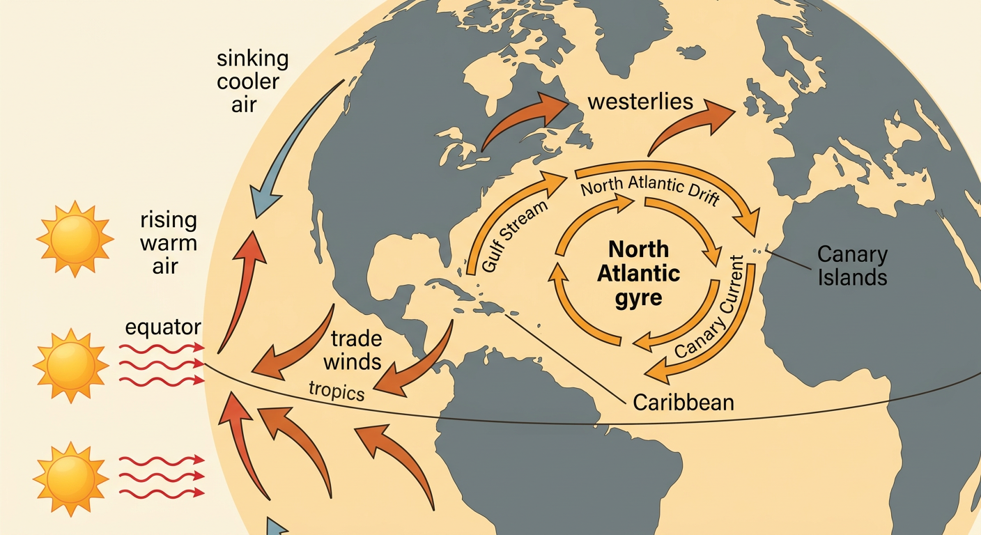
Ocean travel depended on large circulation patterns in the atmosphere and oceans. The equator receives more direct solar energy than the poles, creating unequal heating. Warm air rises near the equator, moves through the atmosphere, cools, and sinks in other regions. These movements help produce trade winds in the tropics and westerlies in the middle latitudes. Earth’s rotation deflects moving air and water to the right in the Northern Hemisphere and to the left in the Southern Hemisphere. This effect, combined with winds and continents, helps form large ocean gyres. In the North Atlantic, the gyre turns clockwise. Westward trade winds could carry ships from the Canary Islands toward the Caribbean, while westerlies farther north helped return ships toward Europe. Sailors did not create these patterns, but they learned to plan routes around them.
Mapping Major Voyage Routes
Maps reveal that major voyages followed winds, currents, coastlines, and known stopping points rather than straight lines. In 1492, Christopher Columbus sailed south to the Canary Islands and then west with the northeast trade winds, reaching islands in the Caribbean. On the return, his ships traveled north before turning east with the midlatitude westerlies. Vasco da Gama’s expedition sailed around the Cape of Good Hope, stopped at East African ports, and crossed the Indian Ocean to India with regional pilot knowledge and favorable winds. Ferdinand Magellan’s expedition crossed the Atlantic, passed through the strait at South America’s southern end, and entered the Pacific. After Magellan’s death, Juan Sebastián Elcano completed the first circumnavigation in 1522. Comparing the routes shows how geography, supplies, weather, and navigation knowledge shaped where ships traveled and where empires later established ports.

Competition and Overseas Expansion
Political competition encouraged European rulers to fund voyages and claim overseas territory. Portugal built a network of fortified trading posts around Africa and in the Indian Ocean to influence maritime commerce. Spain sponsored westward voyages and later conquered large territories in the Americas. Because both monarchies claimed newly reached lands, they supported the 1494 Treaty of Tordesillas, which divided claimed areas outside Europe along an agreed line. Other European powers, including England, France, and the Netherlands, later challenged Iberian control by sponsoring voyages, settlements, and trading companies. Competition increased mapmaking, naval investment, and the movement of goods across oceans. It also produced warfare, colonization, enslavement, forced labor, and the seizure of Indigenous lands. For example, Spanish conquest in the Americas brought wealth to Spain while causing devastating losses for Indigenous peoples through violence, exploitation, and epidemic disease.

Evidence-Based Cause-and-Effect Conclusion
A strong historical conclusion explains multiple causes, supports claims with evidence, and identifies several effects. One possible claim is that European oceanic expansion occurred because rulers and merchants had powerful economic and political goals, while navigation technology and circulation patterns made long voyages more achievable. As primary-source evidence, Columbus’s 1493 letter emphasized valuable resources and opportunities in the lands he encountered, showing his interest in wealth and royal support. Route maps provide additional evidence: his westward and eastward paths followed different wind belts. A scientific circulation model explains why those wind patterns were dependable enough to influence planning. The voyages then increased global trade and European political power, but they also caused colonization, forced labor, disease, and population loss among Indigenous peoples. Historians should compare sources because explorers’ reports often promoted their own achievements and could omit or distort Indigenous experiences.
